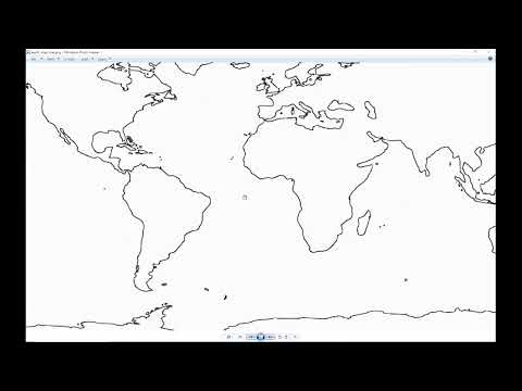
Orbital is a live International Space Station tracker built in Processing (Java). It pulls telemetry from the Where the ISS At? API and renders the station's current position over a hand-drawn contour map of Earth — updated every 10 seconds.
Windows only. Closed source. Binary available in Releases.
- Position — latitude and longitude plotted live on the map
- Altitude — current orbital height in kilometers (typically ~420–430 km, low Earth orbit)
- Velocity — current speed in km/h
- Visibility — whether the ISS is in daylight, eclipse (shadow), or the terminator zone
All telemetry displayed in the upper left, refreshed every 10 seconds.
The visuals are intentional. No clutter, no photorealism — everything is drawn in values of gray against a dark field.
- Earth map — hand-traced contour drawing of the continents and major oceans. Started from a flattened projection, simplified down to clean outlines.
- ISS icon — a custom silhouette illustration of the station. Scalable with
+/−keys. - Target reticle — a circle around the ISS icon so your eye lands on it immediately.
- Window — fully resizable. The map and station scale with it.
The aesthetic was inspired by real and imaginary interfaces — the kind of display you'd expect to see in a facility that actually tracks things.
- Language: Processing (Java)
- API: Where the ISS At? —
https://api.wheretheiss.at/v1/satellites/25544— returns latitude, longitude, altitude, velocity, visibility - Update rate: Every 10 seconds (API updates every 5s; 10s is sufficient and less aggressive)
- Frame rate: 60fps continuous redraw — the window title updates with station data on every frame
- Codebase: ~239 lines
- Platform: Windows 10 or later

See Releases for the Windows binary.